
The images were captured by the Copernicus Sentinel-2 mission, a duo of Earth observation satellites, over north-east Queensland, during floods in February. High resolution images were released late last week.
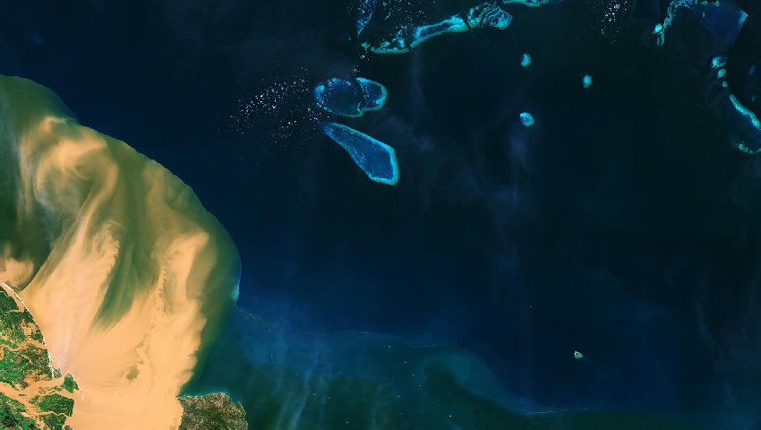
They show a very large amount of sediment gushing into the Coral Sea, close to the Great Barrier Reef lagoon. In those floods, parts of Queensland received more than their annual rainfall in less than a week, with the downpour causing millions of dollars’ worth of damage.
That included homes lost and and some 500,000 livestock destroyed.
The Sentinel image was captured a few days after the torrential rain and shows muddy waters flowing from the Burdekin River into the Coral Sea.
The Burdekin River rises on the northern slopes of Boulder Mountain and flows almost 900 kilometres to the Coral Sea. The Burdekin is one of Australia's larger rivers by discharge volume and is a major contributor of sediment and flows of freshwater to the Great Barrier Reef lagoon.
The 2,000-kilometre Great Barrier Reef, the world’s largest coral reef, extends almost 350,000 square kilometres and comprises 3,000 interlinked reefs and 900 coral islands, divided by narrow passages.
The reef was declared a UNESCO World Heritage Site in 1981.
ESA said the sand-colour sediment plume from the Burdekin floodwaters can be seen stretching over 35 kilometres from the coast, dangerously close to the vivid turquoise reef. Blues of the coral contrast with the deeper dark coloured waters of the Coral Sea.
ESA said the reef suffered regular damage and more than half had disappeared over the last 30 years because of climate change, coral bleaching and pollution.
The large quantities of sediment that flow out from rivers carry agricultural chemicals and fertilisers from inland farms. As well, the sediment blankets the coral, reducing the amount of light reaching the coral. It can also cause cause potentially harmful algae blooms.
Data from Copernicus Sentinel-2 plays a key role in providing information on pollution in lakes and coastal waters.
Sentinel-2, comprising satellites Sentinel-2A and Sentinel-2B, is part of the European Union Copernicus Earth observation program, producing high resolution imagery in the visible, infrared and near infrared spectrum. They cover the Earth every five days from 56 degrees south to 84 degrees north.
Sentinel-2A was launched in 2015 and Sentinel-2B in 2017.
Make Space Connect a preferred news source on Google.