
Victoria is the first state or territory with access to this revolutionary image map, which is 25 times more detailed than comparable maps produced by the Australian government.
The researchers from the University’s Faculty of Information Technology said this has the potential to help with fire prevention, agricultural planning, flood modelling, pollution management, and mine site monitoring and rehabilitation.
Project lead and senior research fellow the IT faculty Dr Francois Petitjean said Earth observation satellites had for years provided information about large-scale agricultural and environmental and climate problems.
“But the pictures we used to see were largely static and unreliable,” he said.
“We’re entering a new era in Earth observation, with latest-generation satellites starting to produce images of Earth frequently, in high resolution and at no charge to end users.
“We now have an unprecedented opportunity to monitor the dynamics of our region – and country – over time and establish a course of action that reflects the changing nature of the environment.”
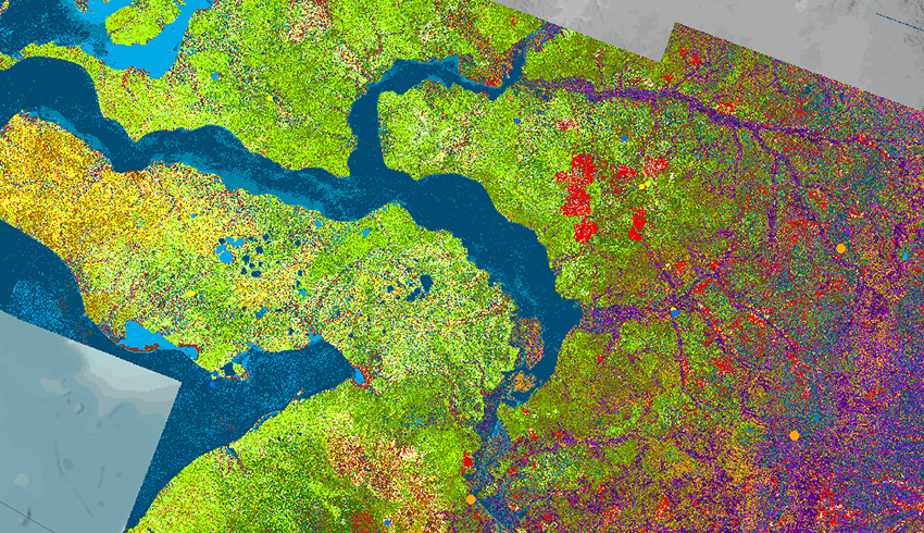
The data is sourced from the ESA Sentinel-2 satellite and comprises more than 4,300 images with resolution down to 10 metres.
“This very colourful map shows great potential for refined modelling of the state’s vegetation, highlighting possible improvements that may be required. We’re currently looking into how we can replicate this for other states and territories in Australia,” Dr Petitjean said.
Researchers see a range of scenarios in which this mapping could be very useful.
For fire management, it’s critical to know condition of trees and grasslands, particularly their vegetation water content and biomass, in order to produce high-quality fuel-load maps. Those can be used to model how bushfires spread and how prescribed burns can be conducted.
For agricultural planning, knowing the type of crops and stress over the territory is important for optimising irrigation and use of pesticides and herbicides. The data can also be used to forecast potential exports through yield estimates.
In flood management, predicting water levels after a rain event requires precise knowledge of soil rain absorption, dictated by the type of vegetation.
Pollution can be better managed through mapping privately and publicly owned vegetation and assessing different types of pollutants a city can safely absorb.