
Since its launch on 23 June 2015, the Airbus-built Copernicus Sentinel-2A satellite has been delivering high-resolution optical imagery for many services and applications including agricultural and forestry management.
Together with its twin satellite Sentinel-2B, launched on 7 March 2017, the mission has become the most widely used of the whole Copernicus satellite family, with more than 60 per cent of all Copernicus downloads coming from Sentinel-2 since the start of operations.
Both of the Copernicus Sentinel-2 satellites carry an innovative wide swath high-resolution multispectral imager (MSI), also built by Airbus, which covers 13 spectral bands for detailed imaging of Earth’s land masses and vegetation.
The combination of high resolution, novel spectral capabilities, a swath width of 290 kilometres and frequent revisit times provides unprecedented views of Earth. The mission is based on a constellation of two identical satellites in the same orbit, 180 degrees apart for optimal coverage and data delivery.
Together they cover all Earth’s land areas, large islands, inland and coastal waters every five days at the equator and every three days in central Europe.
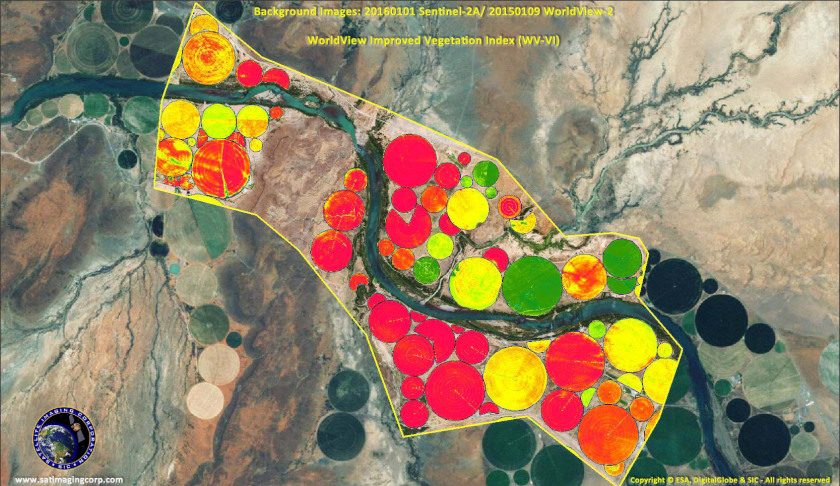
The mission provides information for applications such as agricultural and forestry monitoring or for helping manage food security. Satellite images can be used to determine various plant indices.
Geophysical variables such as leaf chlorophyl content or leaf water content can be determined thanks to the rich spectral sampling offered by the mission. This is particularly important for effective yield prediction and applications related to Earth’s vegetation.
As well as monitoring plant growth, Sentinel-2 can be used to map changes in land coverage and to monitor the world’s forests. It also provides information on pollution in lakes and coastal waters.
Images of floods, volcanic eruptions and landslides contribute to disaster mapping and help humanitarian relief efforts. In addition although not originally designed for it, the Sentinel-2 satellites can help detect floating marine debris.
Getting the vast amount of Sentinel-2 data to the ground is no problem – in 2019 the mission delivered nearly 390 TB per month – as it is using the Airbus owned and operated European Data Relay System (EDRS) to transmit data to the ground.
EDRS is a network of geostationary satellites and low Earth orbit satellites, carrying a laser communication terminal. The system, also known as the SpaceDataHighway, provides secure and fast communication services for many satellites including Sentinel-1 and Sentinel-2.
It contributes to the timely availability of data particularly for time-critical applications such as environmental monitoring, emergency response and security missions.
While Sentinel-2A celebrates its fifth year in orbit, the next pair of satellites – Copernicus Sentinel-2C and -2D – is taking shape in the Airbus satellite integration centre in Friedrichshafen (Germany).
The Optical Communications Payload (OCP) has just been integrated into the "C"-model and has successfully passed its final tests. Integration activities of the "D"-model are progressing in parallel.
Make Space Connect a preferred news source on Google.